
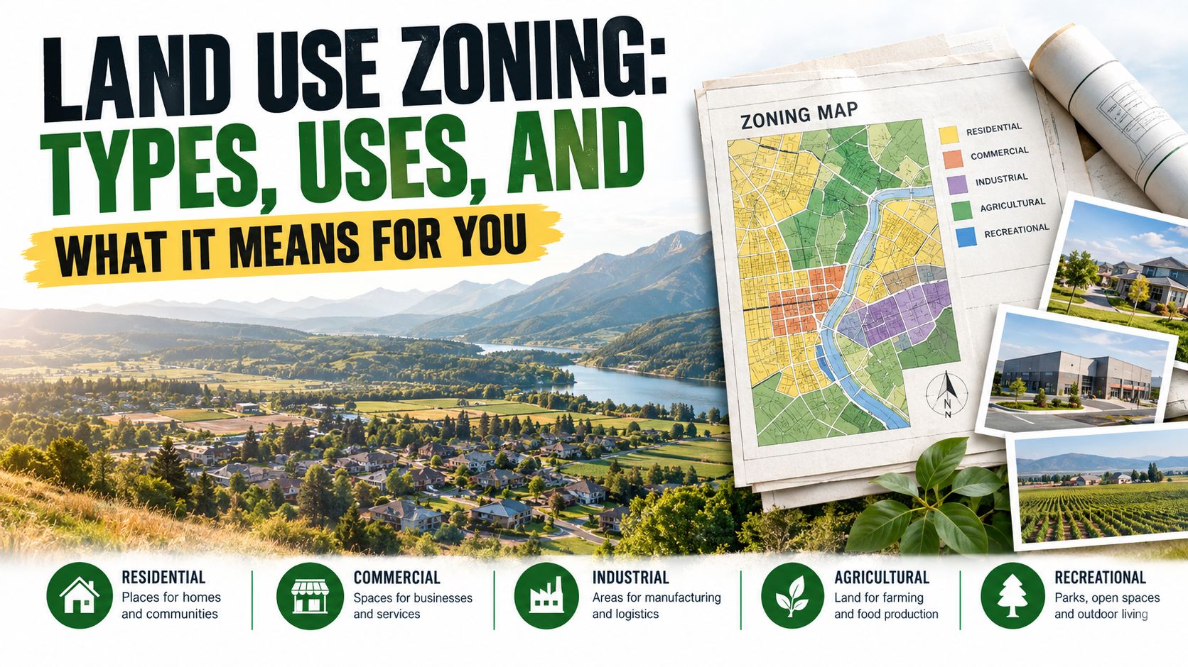
You've found a five-acre parcel online that looks almost too affordable to ignore. The photographs show open sky, a rough access road, and plenty of room for a cabin, workshop, or small homestead. Then you notice a short listing code, perhaps “A-1,” “R-R,” or “R-3,” and realize the parcel's price says nothing about what you're legally allowed to do there.
That code is part of land use zoning, the local rule system that controls how property may be used and developed. Zoning can decide whether you may build a home, place a manufactured house, keep livestock, operate a business, install an accessory dwelling, or develop a solar array. It also controls less obvious details, including where a structure can sit, how tall it may be, how much parking it needs, and whether the parcel has enough usable area to support the plan.
Table of Contents
- Why Zoning Matters When You Buy Land
- The Main Zoning Types Explained Simply
- How to Find a Property's Zoning Designation
- What Uses Each Zone Actually Allows
- Variance vs Rezoning and When to Use Each
- Beyond the Label Implementation Rules That Decide What You Build
- A Pre-Purchase Zoning Checklist for Land Buyers
Why Zoning Matters When You Buy Land
A deed gives you ownership. It doesn't automatically give you permission to build.
Suppose you buy the inexpensive rural parcel, pay the seller, and receive the deed. Later, you learn that the Rural Residential district prohibits manufactured housing. Or the Agricultural district requires a larger minimum parcel before a dwelling is allowed. A Commercial district may permit shops, offices, or storage but prohibit a private residence as the primary use. The land is yours, yet the project you imagined may not be legal.
The same problem can affect smaller plans. A buyer might want to place a cabin, park an RV while building, dig a well, install septic, or keep a few animals. Each activity may involve zoning, building regulations, health rules, road-access standards, or separate county approvals. A cheap parcel becomes expensive when the buyer discovers that the intended use requires a conditional permit, a variance, a larger lot, or infrastructure the site can't support.
Practical rule: Treat the zoning code as part of the property itself. Before you evaluate the view, evaluate the rules.
Zoning is a location-management system
Municipalities use zoning to separate or organize land uses. A community may place homes away from heavy industrial activity, reserve commercial corridors for businesses, protect farmland from scattered development, or limit construction near waterways. The system usually answers three practical questions:
- What may happen here? This covers uses such as a single-family home, retail store, warehouse, farm operation, or utility facility.
- Where may it happen? Setbacks, lot coverage, access rules, and building envelopes control placement.
- What conditions apply? Parking, height, landscaping, drainage, occupancy, and review requirements can change the feasibility of an otherwise permitted use.
Zoning became a major municipal land-use tool in the United States during the early twentieth century. Los Angeles adopted what's widely cited as the country's first municipal zoning ordinance on July 25, 1904, and New York City adopted the first major U.S. zoning ordinance on July 25, 1916. By the end of 1916, 8 cities had adopted zoning ordinances. By 1926, 68 additional cities had done so, and by 1936, 1,246 more municipalities had adopted ordinances covering roughly 70% of the U.S. population, as summarized in the history of zoning in the United States.
The Supreme Court's 1926 Euclid v. Ambler Realty decision upheld zoning as constitutional, which helped accelerate adoption across the country. Zoning still affects major housing markets. The 2019 National Longitudinal Land Use Survey covered about 1,700 jurisdictions across the 50 largest U.S. metropolitan areas, illustrating the reach of modern land-use regulation in the HUD User Cityscape publication.
The Main Zoning Types Explained Simply
Think of zoning as a system that changes as you move from a city center toward open country. The names and codes vary by jurisdiction, but the broad categories help you interpret what a parcel may support.
Residential districts
Residential zoning generally supports housing. A low-density district, often labeled something such as R-1, may allow detached single-family homes on relatively large lots while excluding duplexes, townhomes, and apartment buildings. A higher-density district, perhaps labeled R-3, may allow smaller lots, townhomes, or small apartment buildings.
The code matters more than the letter. One county's R-1 district may allow accessory dwelling units, while another may restrict them. One community may allow manufactured homes in a residential district, while another may require a special district or separate approval.
Mixed-use districts
Mixed-use zoning combines activities that are often separated elsewhere. A building might contain a shop, café, or office on the ground floor and apartments above. These districts can support walkable development, but they may also carry design standards, parking requirements, sign rules, and limits on operating hours.
Commercial districts
Commercial zoning ranges from neighborhood retail to larger auto-oriented corridors. A neighborhood commercial district might allow a small grocery, personal-service business, or office. A heavier commercial district may permit vehicle sales, repair uses, storage yards, or larger retail structures.
A commercial designation doesn't automatically mean you can live there. Residential use may be prohibited, limited to an upper-floor unit, or subject to a special approval.
Industrial districts
Industrial districts support employment and production. Light industrial areas may allow assembly, fabrication, warehouses, or contractor yards with controls on noise, traffic, and outdoor storage. Heavy industrial districts are more likely to sit near rail lines, ports, or major freight routes and may involve stricter environmental and safety regulation.
Agricultural, rural, and conservation districts
Agricultural zoning protects farming and may allow crop production, barns, livestock, farm stands, or related activities. A dwelling may be allowed only when the parcel meets a minimum acreage or when the home supports an active agricultural operation. In some jurisdictions, the minimum can reach 40 or 80 acres, so never assume that a rural-looking parcel is buildable.
Rural, resource, and conservation districts often cover forests, range, watersheds, steep land, or environmentally sensitive areas. They may allow very low-density homes, forestry, grazing, or recreation while restricting subdivision and intensive construction.
Overlays sit on top of the base zone. A floodplain, historic, shoreland, wetland, scenic, or conservation overlay can add review requirements or prohibit otherwise acceptable work.
| Zone Category | Typical Setting | Representative Allowed Use |
|---|---|---|
| Residential | Established neighborhoods | Detached home or limited accessory housing |
| Mixed-use | Main streets and town centers | Shop or office with housing above |
| Commercial | Retail corridors and business districts | Retail, services, or office use |
| Industrial | Employment areas near freight routes | Warehouse, assembly, or production |
| Agricultural | Farms and open countryside | Crop production, barns, and qualifying dwellings |
| Rural or resource | Forest, range, or remote land | Low-density housing, forestry, or grazing |
| Conservation | Watersheds and sensitive land | Limited recreation or protected open space |
How to Find a Property's Zoning Designation
Start with the parcel, not the listing description. A real estate website may identify a zoning code, but that information can be outdated, abbreviated, or copied from an incomplete record.
Begin with the official parcel map
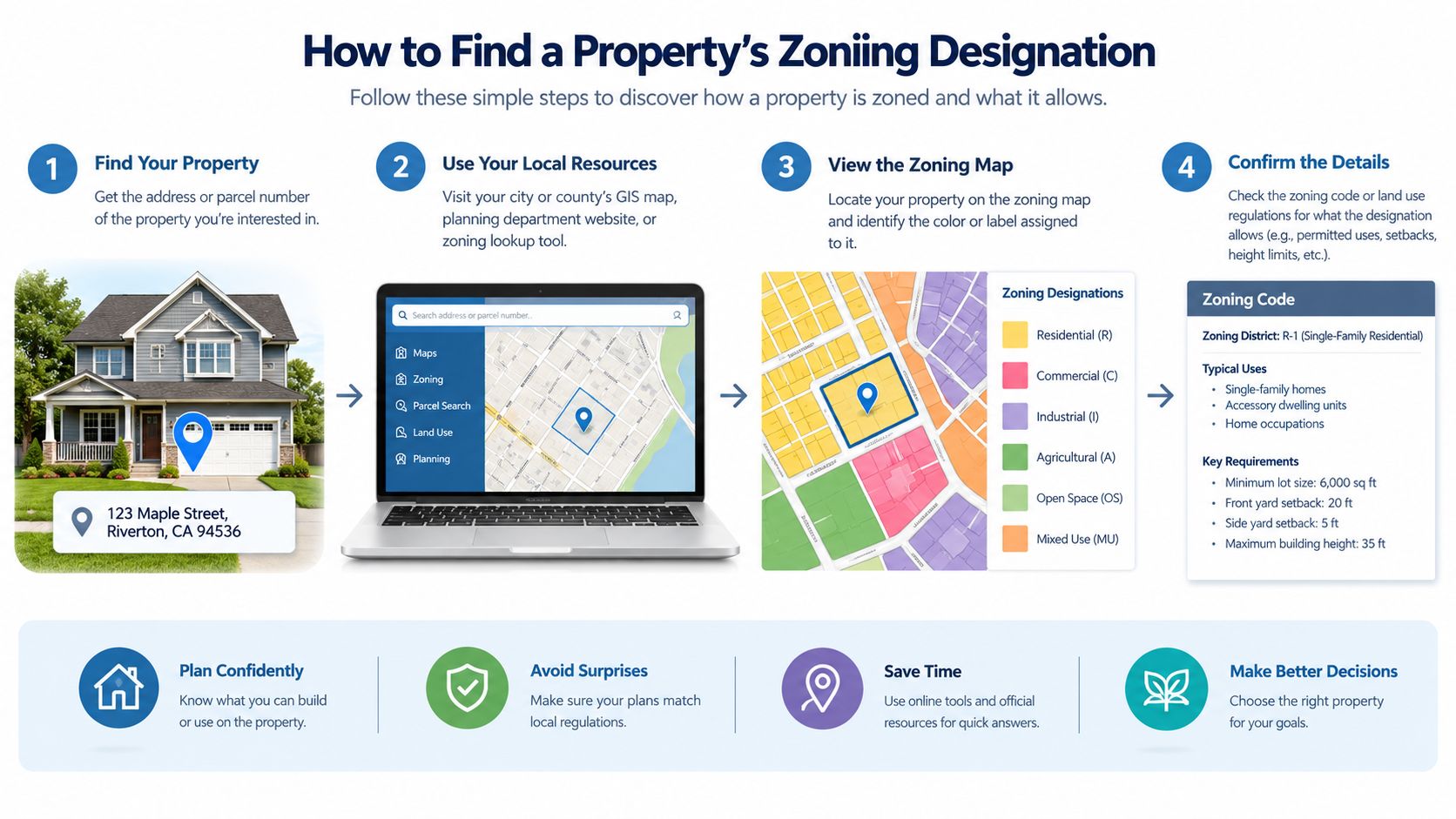
Search for the county's GIS parcel viewer. You'll often find it by searching the county name plus “GIS parcel map,” “property search,” or “planning map.” Enter the parcel's assessor parcel number, commonly called the APN, or use the street address if one exists.
The map popup may show the parcel boundary, acreage, zone code, floodplain layer, tax account, and other useful details. Save the parcel number and take a screenshot of the map, but treat the popup as a starting point rather than the final legal answer.
Read the map and ordinance together
The official zoning map tells you which district covers the parcel. The zoning ordinance tells you what that district means. Search the planning department's website for the district code, permitted-use table, dimensional standards, definitions, and conditional-use procedures.
If the parcel lies inside city limits, check the municipal planning office rather than relying only on the county map. Counties commonly regulate unincorporated land, while cities may maintain their own zoning map and development code.
Third-party property sites can help you discover the code quickly, but verify it through the government source. A boundary may have changed, an overlay may be missing, or the listing may confuse a tax classification with a zoning district.
Call when the map leaves questions
A planner can often clarify issues that a public map doesn't explain. Give the staff member the APN and ask:
- What's the current base zoning district?
- Are floodplain, wetland, historic, shoreland, or other overlays present?
- Are any map amendments, rezonings, or plan updates pending?
- Is the parcel inside a future sewer, annexation, or service boundary?
- Is the intended use permitted, conditional, temporary, or prohibited?
Modern research shows why a single zone label isn't enough. The National Zoning and Land Use Database covers more than 2,600 U.S. municipalities and records over 200 zoning characteristics per district, including lot size, density, parking, and building height. Those details often decide whether a parcel works.
What Uses Each Zone Actually Allows
A zoning district doesn't answer “Can I build?” in one word. It answers whether a specific use is permitted, conditionally permitted, temporary, accessory, or prohibited.
Consider a five-acre parcel in an A-1 agricultural district. The district may allow farming and livestock, but a dwelling could depend on minimum acreage, road access, septic approval, or whether the county requires an agricultural connection. A farm-related barn may be easier to approve than a permanent residence, while a commercial event venue may require a conditional-use permit.
A single-family residential parcel usually offers the clearest path to a conventional home, but it may not allow every alternative. A backyard cabin might count as an accessory structure, an ADU, or a second dwelling. A tiny home on wheels might be regulated as an RV rather than a residence. A tiny home on a permanent foundation may be treated as a dwelling and must meet building and utility requirements.
Manufactured housing deserves separate attention. Some districts allow manufactured homes only in designated areas, while others distinguish between older and newer units, foundation types, installation standards, or architectural requirements. The year 1976 can matter because federal manufactured-housing standards changed then, but the local code still controls whether a particular unit may be placed on the parcel.
| Zone Type | Single-Family Home | Tiny Home / ADU | Manufactured Home | Livestock | Home Business |
|---|---|---|---|---|---|
| Low-density residential | Often permitted | May be accessory or conditional | District-specific | Usually limited | Often permitted with conditions |
| Higher-density residential | Often permitted | May be allowed as an ADU | Varies by code | Commonly restricted | Usually limited |
| Agricultural | May require acreage or conditions | May require dwelling approval | Often subject to district rules | Commonly supported | May require farm connection |
| Rural residential | Often permitted with site rules | Highly variable | May be restricted | Limited or conditional | Often allowed at small scale |
| Commercial | Usually restricted or secondary | May be prohibited | Rarely a standard use | Generally prohibited | Business use is central |
| Industrial | Usually not the primary use | Generally restricted | Generally restricted | Generally restricted | Business use depends on impacts |
Accessory structures also have their own thresholds. A shed, garage, barn, or workshop may be limited by floor area, height, placement, or relationship to the main dwelling. Some counties won't approve a large accessory building before a primary residence exists.
Off-grid plans add another layer. Solar panels, a private well, septic, and water storage may be physically practical but still require approvals from planning, building, environmental health, or state agencies. A home business may be allowed until customer visits, signage, deliveries, noise, or outdoor storage change its classification.
Variance vs Rezoning and When to Use Each
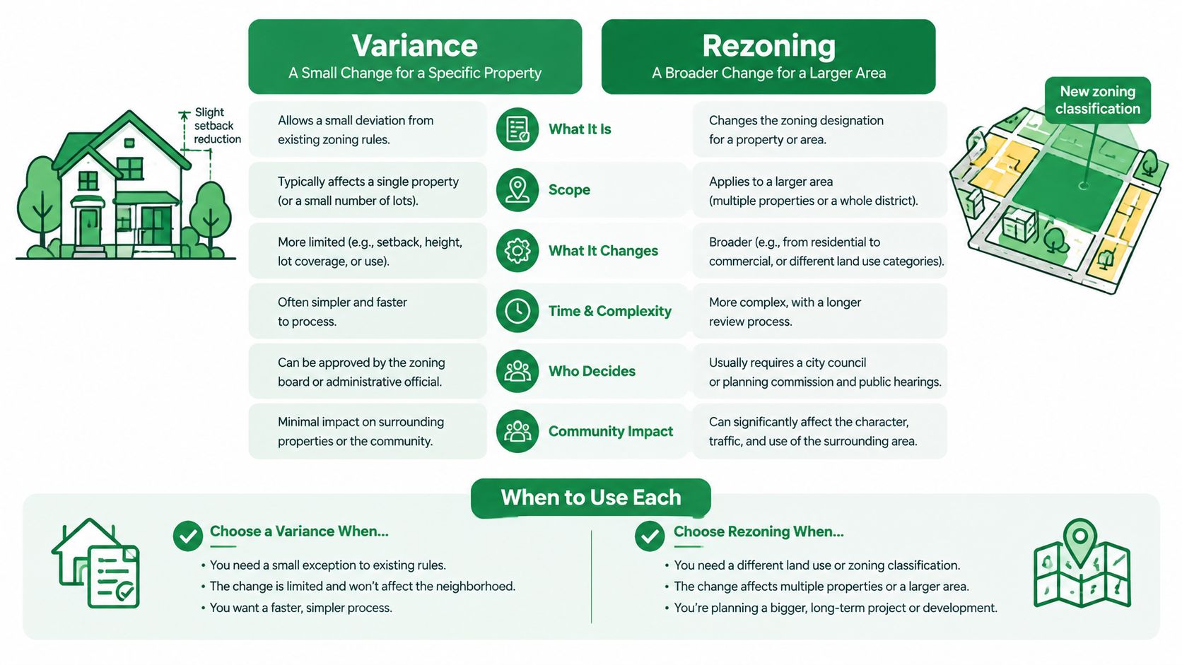
A variance asks for relief from a particular development standard while leaving the zoning district unchanged. You might seek one because a parcel's unusual shape makes the required side setback impractical, or because a parking minimum cannot fit alongside an existing structure.
A rezoning changes the parcel's official district. It's the appropriate tool when the proposed use doesn't belong in the current category, such as requesting residential zoning for land currently designated agricultural or industrial.
The two requests solve different problems
A variance usually addresses a physical hardship tied to the lot. The application may include a site plan, photographs, drawings, a hardship explanation, and notice to nearby owners. A zoning board of appeals or planning commission reviews the request, depending on local procedure.
Rezoning is broader and more political. The applicant typically submits a formal application, explains the proposed district, provides a site plan or concept plan, attends a public hearing, and seeks recommendations and votes from bodies such as the planning commission and city council or county commissioners.
A variance bends a rule for a difficult parcel. Rezoning changes the rulebook for that parcel.
The approval theory matters. Variances are more persuasive when the hardship comes from unusual lot conditions rather than the owner's preferred project. Rezoning is more credible when nearby parcels already support similar uses and the request fits adopted planning policies.
Cost and timing require local confirmation
Fees vary widely by jurisdiction, project complexity, hearing requirements, and professional assistance. A variance may involve an application fee in the $500 to $2,000 range, while rezoning may cost $2,000 to $10,000 or more, before consultant expenses. These ranges come from the requested planning framework, not a universal fee schedule, so ask the local planning office for its current fee sheet before budgeting.
A variance may take roughly 60 to 120 days. Rezoning often takes 4 to 12 months because it can require multiple reviews and legislative action. Those timelines also vary by meeting calendars, completeness of the application, environmental review, and public opposition.
Before choosing either route, ask the planner whether the problem is really zoning. A failed septic test, inadequate road frontage, or floodplain restriction may require a different approval and won't disappear through rezoning. For a procedural walkthrough, review this step-by-step guide to rezoning property.
Beyond the Label Implementation Rules That Decide What You Build
Two parcels can share the same zoning code and still have very different development potential. The difference usually appears in the buildable envelope, the portion of the property where a compliant structure can fit.
Start by drawing the parcel boundary, then remove the front, side, and rear setbacks. Next, account for maximum lot coverage, impervious-surface limits, height restrictions, driveway access, parking, drainage, and any easements. A large parcel with an awkward shape, steep slope, or narrow road frontage may offer less practical building area than its acreage suggests.
Rules that shrink the usable site
Setbacks create separation from roads and neighboring properties. Lot-coverage limits restrict the share of the parcel occupied by buildings, while impervious-surface rules may include driveways, patios, and parking areas. A height limit can affect a barn, workshop, or second-story design.
Parking minimums deserve special attention because they consume land that buyers often assume is available for buildings, gardens, or septic fields. Minimum dwelling-size rules can also eliminate the small-cabin plan that made a parcel attractive in the first place.
Access is equally important. The county may require public-road frontage, an approved driveway location, sight-distance standards, or a recorded shared-access easement. A legal easement doesn't guarantee that emergency vehicles, construction equipment, or utility installers can use it without upgrades.

Overlays and non-zoning approvals
Floodplain, historic, wetland, scenic-corridor, and shoreland overlays can modify the base district. They may require elevation studies, design review, environmental permits, or limits on grading and vegetation removal.
Off-grid buyers should separate zoning from other regulatory systems. A planning department may allow a residence, while the health department controls the well and septic system. Gray-water disposal, solar visibility, building safety, and HOA covenants may come from separate authorities or private restrictions.
A parcel-level drawing can expose these conflicts before closing. If the proposed house, driveway, well, septic field, parking spaces, and accessory structures don't fit on paper, don't assume the site will somehow work in the field. Buyers considering a future division should also review this guide to subdividing land before treating extra acreage as automatically developable.
A Pre-Purchase Zoning Checklist for Land Buyers
Use the checklist before you make the purchase nonrefundable. The purpose isn't to turn you into a planner. It's to make sure the parcel can support the use that justifies your offer.
Run the parcel through these checks
- Confirm the official designation: Use the county or city GIS map with the APN, then record the base zone and every visible overlay.
- Read the ordinance: Pull the complete district text, permitted-use table, conditional-use standards, definitions, and dimensional requirements.
- Test the buildable envelope: Draw setbacks, lot-coverage limits, height restrictions, parking, access, easements, and space for wells or septic.
- Verify the intended use: Ask specifically about a cabin, ADU, tiny home, manufactured home, RV, livestock, home business, solar equipment, and accessory buildings.
- Call the planning office: Give staff the parcel ID and ask about pending rezonings, moratoria, comprehensive-plan amendments, annexation, sewer boundaries, and overlay reviews.
- Tie findings to closing: Keep zoning answers with the survey, financing plan, inspection period, and closing schedule. If the project depends on a permit, make that dependency clear before you commit.
A zoning map revision can matter as much as the current map. A parcel may be proposed for a different district even though the online record still displays its existing classification. Ask whether a public hearing or amendment is pending, and request written confirmation when the answer affects your purchase.
Utilities need the same discipline. A zoning code may allow a dwelling, but the parcel may lack a road suitable for service, a septic area, or a legal water source. Review how to bring utilities to your land alongside the zoning research so your budget reflects the complete site, not just the sale price.
Before closing: Don't ask only whether the land is zoned residential or agricultural. Ask whether your exact structure, access plan, utility system, and timing can satisfy every agency involved.
If a planner identifies a setback conflict, confirm whether a variance is realistic before you waive due diligence. If the parcel needs rezoning, consider the approval process and holding costs before treating the future use as guaranteed. A survey and written zoning response can prevent you from discovering the problem after ownership transfers.
LandZero offers vacant-land listings organized by state and budget, plus owner-financing options and educational guides covering zoning, utilities, development, and off-grid considerations. Use the information you've gathered to screen a parcel's zoning and buildability, then visit LandZero to review available properties before choosing your next due-diligence call.