
You bought a five-acre parcel with a clear plan: keep one homesite for your family, split off the rest, and perhaps sell the new lots later. Then the planning department asks for a current survey, a preliminary plat, road frontage details, drainage information, utility plans, and proof of legal access. The project that looked like a line drawn across a map turns out to be a regulated approval process.
That's the reality behind how to subdivide land. A parcel may appear large enough for several lots, yet fail because the new parcels lack frontage, usable access, compliant setbacks, or a practical way to receive water, sewer, or septic service. The safest approach is to test buildability before paying for a full design.
Table of Contents
- What Subdividing Land Really Means
- Zoning, Access, and Setbacks You Must Clear First
- The Full Subdivision Workflow From Sketch to Recording
- Realistic Timelines and Where the Time Goes
- Cost Drivers Most Buyers Underestimate
- Pitfalls That Sink Otherwise Promising Splits
- A Pre-Subdivision Checklist Before You Commit
What Subdividing Land Really Means
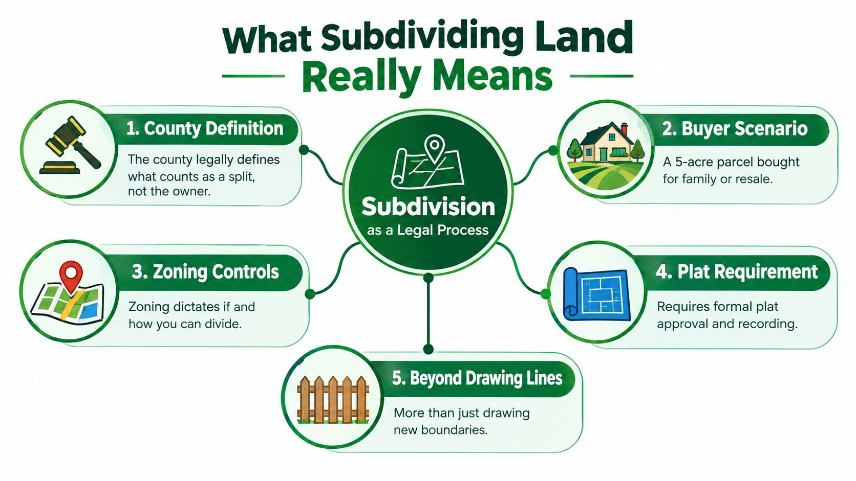
Subdivision means creating legally recognized parcels from a parent parcel under the rules of the local planning authority. The owner doesn't decide what counts as a subdivision. The county, municipality, or other approving authority does, and its definition may distinguish between a minor split, a short plat, a full subdivision, and a simple lot line adjustment.
An informal division is only an idea until the government approves and records the required documents. New boundaries generally need to be based on a current survey and fixed through an approved, registered plan or plat. Ontario's subdivision regulation requires a plan of subdivision to be prepared from a current survey, while New Jersey's rules require subdivision plats to be prepared by a licensed professional land surveyor using a current and accurate survey.
Three concepts buyers often confuse
- Informal split: You sketch a proposed boundary or agree privately to transfer part of the property. That doesn't necessarily create a legal, separately conveyable lot.
- Lot line adjustment: You move a boundary between existing parcels without necessarily creating an additional buildable parcel. The local process may be simpler, but approval is still jurisdiction-specific.
- Recorded subdivision: The authority approves the plat, required conditions are satisfied, and the final document is recorded. The recorded plan establishes the new legal parcels, easements, rights of way, and other matters shown on it.
A paper subdivision can therefore be legally valid while remaining impractical for construction. A proposed lot might meet the area requirement but have no permanent access, insufficient road frontage, an unusable shape, or no viable septic area. Building departments and lenders care about those details because a legal parcel isn't automatically a buildable parcel.
The technical foundation is the survey. In British Columbia, when original corner evidence can't be confirmed, the surveyor must measure between undisputed corners and divide the distance proportionally among the new lots or legal subdivisions. That illustrates the core principle: new lot lines must connect to authoritative boundary evidence, not informal stakes or an owner's estimate.
Zoning, Access, and Setbacks You Must Clear First
Before ordering engineering, read the zoning map and the subdivision code for the specific parcel. The initial question isn't whether the land is large enough. It's whether the proposed lots can satisfy lot area, frontage, access, setbacks, utilities, drainage, and land-use requirements at the same time.
A practical review has three separate layers:
- Zoning and land-use entitlement: This determines whether the proposed use and lot pattern are allowed.
- Subdivision approval: This tests the layout, roads, easements, servicing, drainage, and survey documents.
- Construction permits: These address the actual building, driveway, septic system, grading, and other site work.
Treating those layers as interchangeable causes expensive redesign. A zoning district might permit a certain lot size, while subdivision standards require frontage on a dedicated or improved street. A lot might pass both tests and still need a construction permit that depends on setbacks, driveway access, stormwater controls, or septic approval.
For a plain-language starting point on reading the land-use side of the problem, review this guide to property zoning in the United States. Then confirm every conclusion against the current local code and a planning staff member's written guidance.
Subdivision requirements at a glance
| Layer | Typical Requirement | Where It Is Checked |
|---|---|---|
| Zoning and land use | Permitted use, minimum lot area, density, and setbacks | Zoning map, zoning code, planning department |
| Subdivision approval | Plat format, lot configuration, roads, easements, frontage, and improvements | Subdivision code and planning review |
| Construction permits | Building envelope, driveway, drainage, utilities, septic, and site plans | Building, engineering, public works, and health departments |
Access deserves early attention because it can eliminate an otherwise attractive layout. Confirm whether each proposed lot has direct frontage, a recorded access easement, or another form of permanent legal access accepted by the jurisdiction. Don't assume a dirt track, family agreement, or historical use will satisfy the building department.
Setbacks create a second hidden constraint. Draw the required building envelope on the proposed lot, not just the outer boundary. If the envelope disappears because of a narrow shape, slope, wet area, access corridor, or neighboring restriction, the lot may be divisible on paper but unusable in practice.
The Full Subdivision Workflow From Sketch to Recording
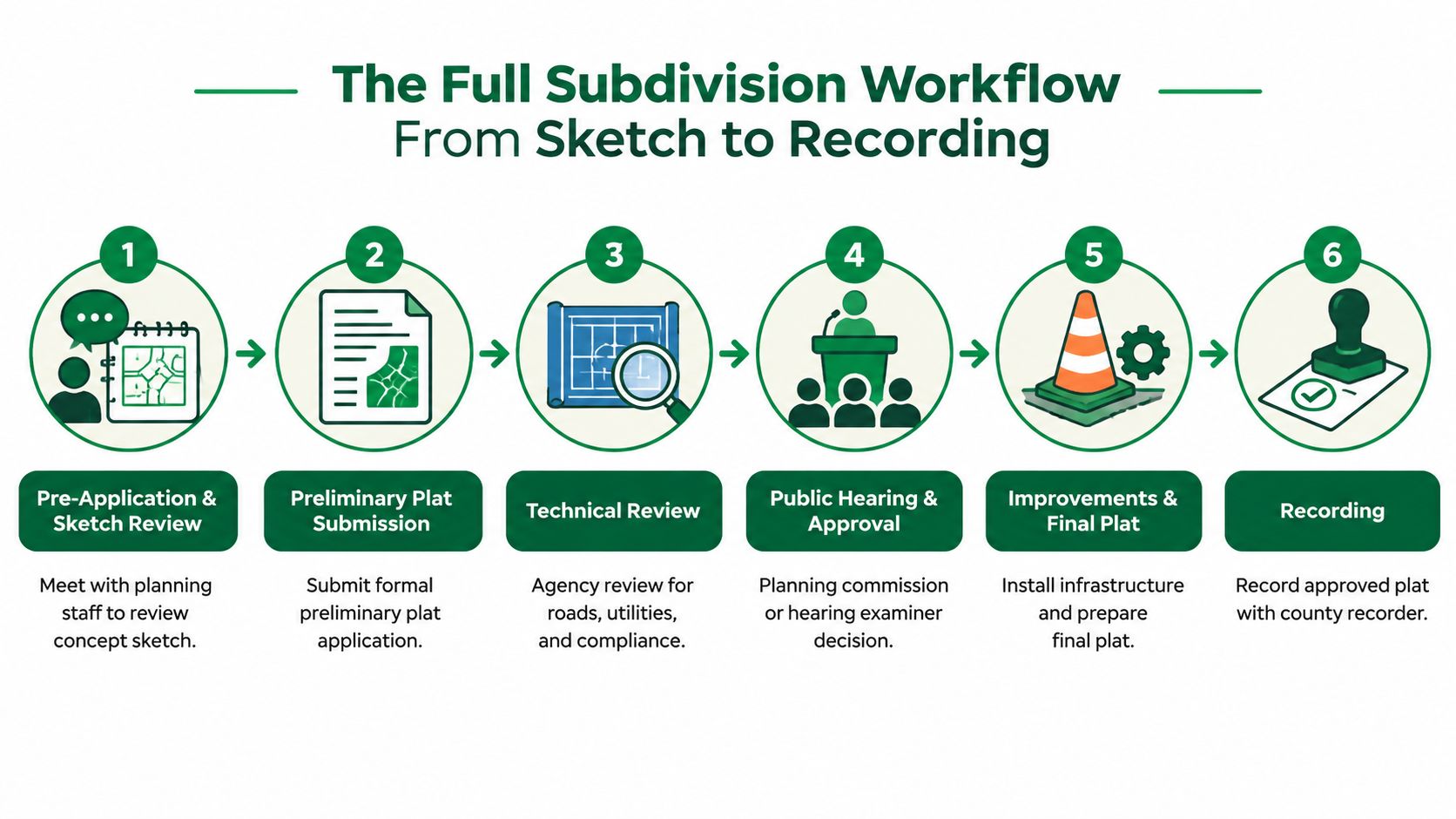
The process usually starts with a conversation, not a finished survey. Bring planning staff a parcel map, basic ownership information, the intended lot count, and a rough sketch showing access. The pre-application meeting can expose fatal issues before you pay for detailed engineering.
The surveyor then establishes the parent parcel's boundaries and prepares the technical base for the layout. Depending on the site, the design team may also need topography, drainage information, utility locations, environmental constraints, and road concepts. A useful explanation of the documents involved appears in this guide to land survey requirements.
Follow the agency's sequence
The preliminary plat is the first formal test of the concept. It typically shows proposed lot lines, access, roads, easements, utilities, drainage features, and other information required by local rules. Planning, engineering, public works, utilities, fire, and environmental reviewers may each comment from a different perspective.
Expect comments and possible resubmittals. A surveyor can correct boundary or plat issues, a civil engineer can address roads and drainage, and a land-use attorney can help interpret conditions, title restrictions, or appeal issues. These professionals work best when they receive the same current base information, rather than designing from conflicting versions of the parcel.
Larger proposals may require a public hearing or action by a planning commission, hearing examiner, or governing body. Approval may be conditional, which means the project still needs improvements, agreements, bonds, revised easements, or other documentation before the final plat is accepted.
Practical rule: Preliminary approval is permission to finish the conditions, not permission to sell imaginary buildable lots.
After required improvements are installed, or an acceptable security arrangement is approved, the team prepares the final plat. The final document must match the approved layout and include the necessary certifications, dedications, legal descriptions, and signatures. Once the county recorder accepts it, parcel identifiers and tax records can be updated, subject to the jurisdiction's procedures.
The most common handoff failures occur when the owner assumes the surveyor handles engineering, the engineer assumes access is already legal, or the applicant submits a final plat before conditions are complete. Assign each requirement to a person, get it in writing, and track the conditions from preliminary approval through recording.
Realistic Timelines and Where the Time Goes
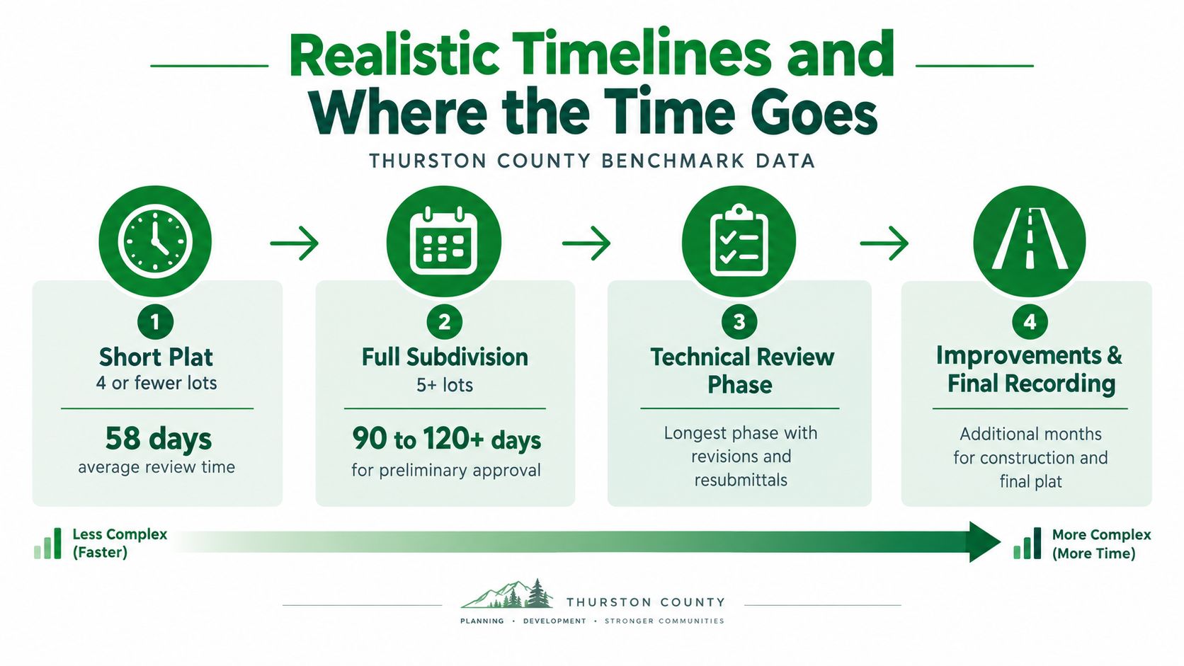
Subdivision schedules vary by jurisdiction and project complexity, but official benchmarks show why a fast resale plan can become unrealistic. In Thurston County, Washington, a short plat for four or fewer lots can take up to 58 days, a large-lot subdivision with five or more lots can take up to 128 days, and a full plat can take up to 148 days, according to the county's division of land bulletin.
Those figures describe approval timing, not necessarily the entire project. After preliminary approval, the same county gives recording deadlines of one year for a short plat, three years for a large-lot subdivision, and five years for a full plat, subject to the applicable rules and conditions in the bulletin.
Conditions can outlast the review
Manitoba's provincial subdivision guide shows how quickly elapsed time accumulates across separate review stages. The sequence includes 5 days for CPB review, 20 days for government review, up to 90 days for council, 60 days for the approving authority, up to 2 years to complete conditions, and 3 weeks for registration. The guide notes that processing can take “six months or longer.”
The important lesson isn't that another jurisdiction's calendar predicts yours. It's that conditional approval can create a long second phase after the initial decision. Roads, drainage, utility commitments, access documents, and survey corrections may need to be completed before recording.
Permitting can also consume meaningful time before subdivision review begins. One planning reference places the zoning permit stage at roughly 1 to 3 months in its development sequence, as shown in this Pennsylvania land development reference. Build your schedule around dependencies, not optimism. A survey can't finalize a layout that fails zoning, and a final plat can't record while required improvements or legal documents remain unresolved.
Cost Drivers Most Buyers Underestimate
The first budget mistake is asking for one subdivision price before defining the project. A two-lot adjustment with existing frontage and utilities is a different assignment from a multi-lot plan requiring new roads, drainage facilities, utility extensions, and recorded easements.
Use the table below as a budgeting framework, not a price quote. Professional fees and agency charges vary by location, while condition-driven work can expand after technical review.
Subdivision cost drivers
| Cost Category | Typical Range Signal | What Drives It |
|---|---|---|
| Current boundary survey and plat | Fixed-to-variable professional scope | Parcel complexity, title evidence, corner recovery, proposed lot count |
| Topographic and site survey | Variable | Terrain, drainage patterns, existing improvements, critical areas |
| Civil engineering | Variable to major | Roads, stormwater, grading, utilities, fire access, and required studies |
| Application and review fees | Published or schedule-based | Local fee schedule, application type, resubmittals, and lot count |
| Infrastructure or bonds | Condition-driven and potentially substantial | Road construction, water, sewer, drainage, utility extensions, and agency standards |
| Legal and title work | Variable | Easements, access rights, restrictions, dedications, and revised legal descriptions |
A current survey is not a clerical expense. It may uncover encroachments, gaps, overlaps, missing monuments, or a legal description that doesn't match occupation on the ground. Correcting those matters before plat design is cheaper than redesigning after review, even though the correction itself can add time and professional work.
Engineering is where feasibility often changes. An apparent road alignment may require grading, drainage controls, a turnaround, or a wider right of way. Utility service may require extension agreements or off-site work. Ask the planning and engineering departments which improvements are commonly required for the proposed lot count, and ask whether the agency accepts bonding instead of completed construction.
Keep a separate contingency for condition-completion work. An application fee is visible at the start. The expensive surprises usually appear later, after staff comments define the infrastructure and documentation needed for final recording.
Pitfalls That Sink Otherwise Promising Splits
Many guides reduce the problem to minimum lot size. That's only one gate. A property can meet the area standard and still fail because the new lot doesn't touch a qualifying street, lacks permanent access, violates setbacks, or depends on a survey document the building department won't accept.
Access and frontage are separate questions
Ask two questions instead of one:
- Legal access: Does each lot have a recorded right to reach a public access system or another route the jurisdiction recognizes?
- Qualifying frontage: Does the lot front on a dedicated or improved street in the way the code requires?
An existing driveway doesn't automatically answer either question. Review the deed, title documents, recorded easements, road status, and local code together. In one Arizona example, the Chino Valley development code ties legal access to a public access system or properly recorded plat and withholds a building permit until a compliant Record of Survey is provided.
Survey compliance is another common failure point. A hand-drawn division, old sketch, or unverified boundary may help start a conversation, but it can't replace the current survey and recordable plat the authority requires. If corner evidence is uncertain, the surveyor may need to perform additional research and field work before the lot geometry is reliable.
Setbacks can also make a proposed parcel nonconforming. Draw the buildable area after accounting for roads, access corridors, drainage, slope, and other constraints. Don't market or value a new lot as buildable until the relevant departments confirm that the envelope works.
Rules are moving in different directions
Subdivision law isn't static. Michigan's Land Division Act amendment took effect on March 24, 2026, while a Maryland 2026 bill would restrict local governments from blocking certain conforming subdivisions of improved single-family lots into three or fewer smaller lots. Rhode Island's 2026 overhaul changed the timing of some permit requirements. These examples come from the policy material identified in the project brief, including the Maryland legislative fiscal note.
California's SB 9 lot splits still illustrate the limits of reform. One county notes that SB 9 splits must meet frontage-related conditions and can't be further subdivided under SB 9. The correct question is therefore not “Can I split my land?” It's “Can I create buildable lots with access, frontage, setbacks, and survey documents that the planning office, building department, and lenders will accept?”
A Pre-Subdivision Checklist Before You Commit
Run this review before ordering a full plat or making the subdivision assumption part of your purchase price.
- Zoning verification: Confirm the proposed lot count, use, and density with the current zoning map and code. Pause if staff won't confirm the interpretation in writing.
- Minimum lot area and frontage: Measure every proposed lot against both standards, not just acreage. A narrow parcel with inadequate street frontage is a warning sign.
- Legal access and road status: Verify recorded access and whether the road is dedicated, maintained, and improved to the required standard. Don't rely on a neighbor's permission.
- Utilities and septic feasibility: Ask the utility provider or health department what service evidence is required. Stop if no practical septic area or utility path exists.
- Drainage and topography: Review slopes, drainage routes, wetlands, floodplain issues, and other critical areas before fixing lot lines. A survey alone won't solve a site constraint.
- Current local rules: Check recent amendments, temporary measures, and state reforms with planning staff. A remembered rule from a nearby parcel may be obsolete.
- Surveyor selection: Hire a licensed professional familiar with local plats and recording standards. Be cautious if the quote excludes title research, corner recovery, or revisions.
- Condition budget: Reserve money and time for roads, drainage, easements, utility work, and final-document corrections. If the project only works with no surprises, it probably doesn't work.
Prepare accurate legal land descriptions early, especially when an access easement, boundary adjustment, or title correction may be involved. The description on the deed, the survey, and the proposed plat need to tell the same story.
Buying an already-subdivided parcel may make more sense when the new lot must be usable quickly, infrastructure is uncertain, or the required improvements would overwhelm the land's value. LandZero offers vacant-land listings organized by state and budget, with owner financing through LandZero FlexPay and online purchasing options. Visit LandZero to compare existing parcels before committing your time and capital to a subdivision approval process.