
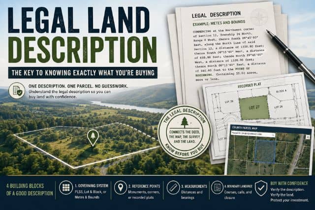
You can be staring at a cheap land listing right now, with a pretty aerial photo, a county map, and maybe a street address that sounds close enough to what you want. Then you click around and realize the listing doesn't clearly show the parcel identifier, the recorded plat, or the exact legal wording that tells you what land is for sale. That gap is where a lot of first-time buyers get stuck, because the legal land description is the document that ties together the deed, title, survey, county records, and the boundaries on the ground.
If you're comparing rural lots, off-grid acreage, or a subdivision parcel, the description is not paperwork trivia. It's the controlling identifier that lets a title company, county recorder, and surveyor talk about the same piece of land without guessing. An address can change, a GPS pin can be off, but the legal description is what carries the parcel through ownership history and conveyance.
Table of Contents
- Why the Legal Description Matters Before You Click Buy
- The Four Building Blocks of a Legally Sufficient Description
- Reading PLSS Descriptions Section by Section
- Decoding Metes and Bounds Calls
- How Lot and Block Descriptions Anchor to a Recorded Plat
- Matching the Right System to Your State and Parcel
- Reading for Risk Hidden Inside the Description
- Finding the Legal Description Before You Buy
- Pre-Purchase Verification Checklist
- Glossary of Description Terms You Will See in Deeds
- Quick Reference Card You Can Keep by the Listing
Why the Legal Description Matters Before You Click Buy
A first-time buyer often starts with the easiest thing to understand, the listing photo. The next stop is usually the address, then the county map, then a parcel search that still feels vague because the map doesn't tell the whole story. That's where the legal description becomes the difference between buying land and buying uncertainty.
The Bureau of Land Management defines a legal description as a written land description based on an approved and filed Federal land survey under the PLSS, or, where authorized, a protraction diagram, and otherwise by metes and bounds tied to monuments or other boundary references BLM land description specifications. In plain terms, it's the language that makes one parcel legally distinct from every other parcel around it. An address points mail to a place, but the legal description points ownership to the exact tract.
Why title, survey, and county records all care about the same wording
County recorders index deeds by the description, title companies rely on it to insure the right parcel, and surveyors use it to locate the land on the ground. That's why a description isn't just a label, it's the written bridge between paper title and physical boundaries. If the wording is incomplete or unclear, the problem doesn't stay on the page, it can affect what you own.
Practical rule: if you can't trace the legal description to a recorded instrument or survey, you don't yet know exactly what's being offered.
This matters most for remote buyers, out-of-state buyers, and anyone comparing vacant land listings online. A map pin can be close and still not prove the parcel line, the easement, or the exclusion language. Before money changes hands, the legal description needs to match the land you think you're buying, not just the land the listing photo suggests.
The Four Building Blocks of a Legally Sufficient Description
A legally sufficient description has one job, identify the parcel to the exclusion of all other land or give a reliable way to locate it from other sources BLM land description specifications. For a buyer, that means the wording has to do more than sound official. It has to point to one specific tract, and it has to do so in a way a recorder, surveyor, or title company can follow without guessing. Survey guidance also treats good parcel descriptions as something that should be plottable, locatable on the ground, and, when applicable, mathematically close minimum standards for parcel legal descriptions. If one of those pieces is missing, the description gets harder to trust.
The four reference pieces that keep a parcel unambiguous
For PLSS-based parcels, Colorado land-record guidance points to the core reference data that make a description readable, including the principal meridian, township and range, section number, quarter section or quarter-quarter section, acreage, and a reception number or deed date/book-and-page reference. Those elements work like a survey address. Each one narrows the tract until the parcel can be tied back to the public record and the ground itself Colorado land-record guidance.
A useful way to read those pieces is in order:
- Principal meridian: the north-south reference line that starts the grid.
- Township and range: the grid location relative to that reference.
- Section or lot identifier: the specific one-square-mile unit or recorded lot.
- Acreage or recording reference: the size or the document trail that ties the parcel to the record.
Metes and bounds descriptions rely on a different set of clues, but the logic is the same. The description needs a point of beginning, boundary calls, monuments or landmarks, and a closing call back to the start minimum standards for parcel legal descriptions. If those pieces are missing, the deed may still look formal, yet it may leave too much room for doubt about where the line runs.
That is where buyers need to slow down. A clean description does not have to be long, but it does have to be complete enough that another professional can put the same tract on the ground and get the same result. When a description leaves out the tie to the record, skips the closing call, or blends one parcel with another nearby tract, the risk is not abstract. It can affect boundaries, easements, or even which slice of land is included in the sale.
Reading PLSS Descriptions Section by Section
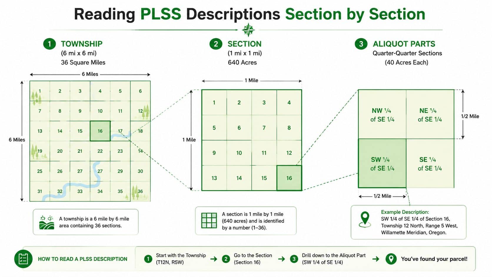
The Public Land Survey System works like a giant grid laid over land. A township is commonly described as 6 miles by 6 miles, and it covers 36 square miles. Each township contains 36 sections, and each section contains 640 acres, which is why a legal description can identify a parcel with just a few survey references PLSS overview and example. Once you see the pattern, the notation stops looking random.
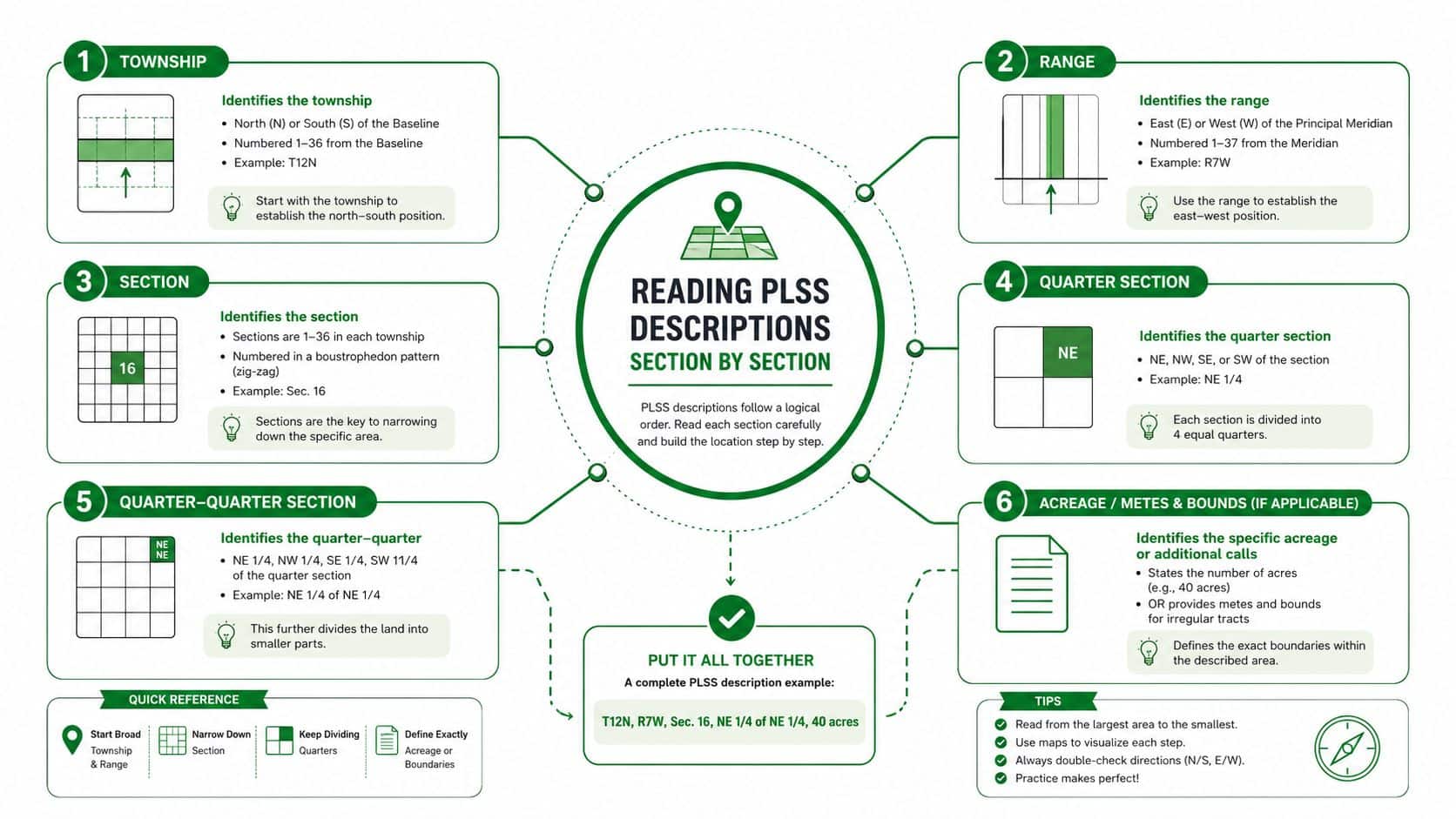
How the grid narrows the parcel
Start with the township, then move to the section, then to the smaller aliquot part. The hierarchy matters because each step narrows the search area. A parcel described as the Northwest ¼ of the Northwest ¼ of Section 10, Township 15 South, Range 3 East is a 40-acre tract nested inside a bigger section PLSS example.
That example is easier to read if you translate it in order:
- Section 10: the one-square-mile section inside the township.
- Township 15 South: the township's north-south position.
- Range 3 East: the township's east-west position.
- Northwest ¼ of the Northwest ¼: the quarter-quarter that narrows the parcel to a smaller part of the section.
The number of states using this grid is often described as roughly 30 in practical land-work materials, but the more important point for a buyer is simpler. If you see township, range, section, and aliquot parts, you're probably looking at a PLSS parcel, and the description is telling you where the tract sits inside a surveyed grid.
A common confusion is assuming the wording gives a street-like address. It doesn't. It gives a survey location, and the survey location is what you need before you can trust a map, title report, or listing claim about the parcel's size and shape.
Decoding Metes and Bounds Calls
Metes and bounds reads like a sentence that walks around a fence line. The format usually has a caption or preamble, a body, and qualifying clauses, and each part does a different job minimum standards for parcel legal descriptions. The body is the part that traces the boundary, while the rest helps you interpret the path.
What the boundary language is doing
A proper metes-and-bounds description usually starts at the point of beginning, then moves through a sequence of course-distance-direction calls, and finishes by closing back to that starting point minimum standards for parcel legal descriptions. The monuments matter too, because a description may refer to iron pins, fences, stones, or other markers that tie the words to the ground.
If you're reading one, separate the words into these jobs:
- Point of beginning: where the boundary trace starts.
- Calls: the direction and distance lines that move the boundary.
- Monuments: the physical markers that support the line work.
- Closing call: the final line returning to the starting point.
Natural monuments and artificial monuments can both matter, but older descriptions get tricky when a monument no longer exists. A stake can rot away, a tree can disappear, and the paper still has to be interpreted. When bearings are based on magnetic or observed north, the observation date and time should be stated to preserve reproducibility minimum standards for parcel legal descriptions.
If a metes-and-bounds deed feels hard to follow, don't rush the geometry. The legal boundary is usually hidden in the verbs, directions, and closing language.
How Lot and Block Descriptions Anchor to a Recorded Plat
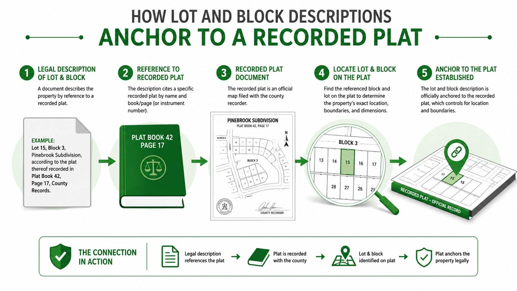
Lot and block descriptions usually read like Lot 12, Block B, of the recorded plat of Desert Mesa Ranch, followed by a recording reference. The key idea is that the description points to a recorded plat map, not just to a list of bearings and distances. Federal specifications also expect the lot or parcel identifier, block identifier if applicable, and the plat or map reference title real estate legal land descriptions.
Why the plat is the real source document
Inside a subdivision, the plat usually shows lot lines, easements, rights-of-way, setback lines, and utility dedications. That means the lot description alone often isn't enough for due diligence, because the map carries the detail. A buyer who skips the plat can miss restrictions that are already baked into the layout.
A simple way to think about it is this. The deed says which lot is yours, and the plat shows what that lot contains. If the plat is the source, then the description is just the pointer.
For people comparing subdivision parcels, one practical resource is this subdivision guide, because plat-based parcels often trace back to the way the original tract was divided. Hybrid descriptions also show up, where a lot-and-block parcel still references metes-and-bounds details or exception language. When that happens, read the plat and the exceptions together, not one at a time.
Matching the Right System to Your State and Parcel
A buyer usually does not need a survey history lesson first. They need a quick read on which legal description system is in play, because that tells them where the rest of the proof lives. The three main systems are PLSS, metes and bounds, and recorded plat survey system, or lot and block. Once you know the system, you know whether to look for township lines, deed calls, or a recorded map.
| System | Where It Shows Up | What Fixes the Boundary | What to Ask For |
|---|---|---|---|
| Government Survey System, PLSS | Most western and midwestern land records PLSS overview and example | Township, range, section, and aliquot parts | Survey plat or federal land record |
| Metes and Bounds | Original thirteen colonies, Texas, Hawaii, and other non-PLSS areas | Bearings, distances, monuments, and point of beginning | Full deed description and any survey exhibit |
| Lot and Block | Subdivisions, planned communities, and many urban and suburban counties | Recorded plat map | Recorded plat or subdivision map |
For mobile readers, a simple table like this works better than a crowded chart. Keep the columns short, and read it left to right as a chain of questions. What system is this, what fixes the boundary, and what document should you pull next? That is the practical test.
Don't trust geography alone
State reputation can point you in the right direction, but it does not control the parcel. A Texas tract can still contain PLSS references in some settings, and a Colorado parcel can still use metes-and-bounds calls. The legal text does the actual work, not the stereotype. If the deed says one thing and the county file suggests another, the recorded description and its supporting documents decide what you should review next.
County records matter more than assumptions. A mailing address and ZIP code do not tell you the survey system, and they do not show whether the parcel sits inside a subdivision, an older metes-and-bounds tract, or a section-based framework. If you can find the legal text early, you can also spot whether zoning, subdivision rules, or lot restrictions may shape how the land can be used. A good place to start is this zoning guide for property buyers, because zoning often explains why a parcel that looks similar on paper behaves very differently in practice.
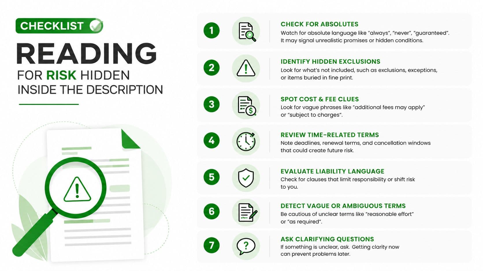
Reading for Risk Hidden Inside the Description
A legal description can appear correct and still conceal an issue. Professional drafting guidance warns that descriptions should be sufficient to plat, locate on the ground, and close mathematically where appropriate, because a description that looks complete on paper can still leave room for boundary trouble minimum standards for parcel legal descriptions. The risk is not only in what the description says, but in what it leaves out.
The hidden problems buyers miss
A quarter-section call can be incomplete if the acreage or controlling reference is missing. A monument described in an old deed may no longer exist. An easement or right-of-way can sit inside the title history and change how usable the land really is, even if the lot size seems fine on paper. The same goes for a basis of bearings tied to magnetic north, because if the reference isn't understood, the plotted line can drift from the intended line minimum standards for parcel legal descriptions.
A useful buyer mindset is to treat the description as a risk-bearing instrument, not a neutral label. Roads, utility corridors, reservations, and other exceptions can reduce access or usable area without changing the parcel name. That's why reading the description with the survey and title materials matters so much.
Watch the exceptions first. Many boundary surprises don't come from the parcel line itself, they come from what the deed says is excluded.
For a broader land-use lens, a zoning overview can help you connect the parcel boundary to what you're allowed to do on it, especially when easements and setback rules overlap LandZero zoning guide. The main takeaway is simple. A description that's technically legal can still be practically risky if it hides access limits, easements, or unclear boundary calls.
Finding the Legal Description Before You Buy
Many first-time buyers start with a listing and then realize the legal description isn't obvious. That retrieval step is its own task. Alberta's land guidance points buyers to practical lookup paths like a certificate of title, tax notice, municipal office lookup, or map-based title search, which matches the same real-world problem U.S. buyers run into when a listing only shows an address or parcel ID Alberta legal land description guidance.
A simple retrieval workflow
Start with the county tax notice or assessor record if you have the parcel ID. That often gives you the legal wording or at least enough of it to trace the parcel in county systems. If that's not enough, use the county recorder or clerk search with the parcel ID, owner name, or recorded instrument reference.
Then ask for the title commitment. Title work usually pulls the legal description into a form that's easier to compare against the deed history, and it's where you can catch mismatches before closing. For federal land or rural PLSS tracts, the BLM records can provide the survey context when the parcel descends from a federal survey BLM land description specifications.
A GIS parcel viewer is useful as a cross-check, but it shouldn't be the only source. The map can confirm whether the parcel shape lines up with the recorded description, yet the legal text still controls.
An address is a starting point. The legal description is the thing you verify before you treat the parcel as the one you want.
If you're researching a parcel that might later need a land-use change, it helps to understand the difference between finding the description and changing the property's use. A rezoning walkthrough can be a useful next step after you've confirmed the parcel itself rezoning guide.
Pre-Purchase Verification Checklist
A listing can look clean and still hide a mismatch. The safest move is to verify the description against the parcel before you send money or sign anything. The steps below pull together the main checks buyers and surveyors use when a parcel is on the line.
Six checks that catch the most expensive mistakes
Match the description to the county GIS layer.
Confirm that the parcel shape, label, and location line up with the legal text, not just with the listing photo.Pull the recorded plat or survey.
If the description points to a plat, that map is the controlling detail source. Read the easements, rights-of-way, and any setback lines on it.Read every exception in the title commitment.
Exceptions can control access, utility use, or portions of the land. Don't skim them.Check the basis of bearings and any curve data.
If the description uses direction data, make sure you know what reference the surveyor used and whether the call is reproducible.Verify acreage and dimensions against the document trail.
The acreage in a listing should not outrank the deed or plat. If they disagree, pause.Confirm the description closes back to the point of beginning.
If it doesn't close, or if it closes only by assumption, the boundary may need professional review minimum standards for parcel legal descriptions.
What to do when something doesn't line up
If the GIS layer and the deed disagree, treat the deed, plat, and survey as the priority documents, then ask a surveyor or title professional to explain the gap. If the parcel appears to include a road, access lane, or utility corridor, check the exception language before you assume the full area is yours. If the listing only shows a tax map and no recorded instrument, you're not done yet.
The safer habit is to verify first and then negotiate. That's the difference between buying a parcel you understand and buying one you'll be decoding after closing.
Glossary of Description Terms You Will See in Deeds
Aliquot part. A fractional part of a PLSS section, such as a quarter or quarter-quarter. Example, the Northwest ¼ of the Northwest ¼.
Point of beginning. The starting point for a metes-and-bounds boundary trace. Example, the deed starts at the point of beginning and returns there at the end.
Principal meridian. The reference line used in the PLSS grid. Example, township and range are measured from a meridian.
Protraction diagram. A survey-based map that can support a legal description when expressly authorized in federal land practice BLM land description specifications.
Monument. A physical marker used to locate a boundary. Example, an iron pin or stone corner.
Basis of bearings. The reference used to set direction lines in a survey. Example, bearings may be tied to magnetic or observed north.
Lot. A numbered parcel shown on a recorded plat.
Block. A group or subdivision unit within a plat.
Plat. A recorded map that shows lots, blocks, easements, and related layout details.
Reception number. A recording reference used to locate a filed document in county records.
Quick Reference Card You Can Keep by the Listing
PLSS. Read township, range, section, and aliquot parts. Biggest risk, missing reference details or confusing the grid with an address. Next step, pull the survey or federal record.
Metes and bounds. Read the point of beginning, the calls, the monuments, and the closing line. Biggest risk, a monument that no longer exists or an exception that trims access. Next step, compare the deed with the survey exhibit.
Lot and block. Read the lot, block, subdivision name, and plat reference. Biggest risk, skipping the recorded plat and missing easements or setbacks. Next step, open the plat before you rely on the lot number.
Hybrid descriptions. Read every part, not just the format that looks familiar. Biggest risk, assuming one system controls the whole parcel when another reference or exception changes the boundary. Next step, ask which document governs the conflict.
Before you buy. Match the legal description to the GIS map, title commitment, and recorded instrument. If any of them disagree, slow down and resolve the mismatch first. The photo can help you like a parcel, but the description tells you what you own.
If you're comparing vacant parcels and want a practical place to start, use LandZero's listings alongside the legal description, not instead of it. Their education library can help you think through land basics while you verify the parcel details that control ownership. Visit LandZero to browse available land and keep your due diligence grounded in the description, not the photo.